


To study our atmosphere and understand climate change, we need to talk about our main source of energy. Have you ever stopped to think what the Earth would be like without the presence of the Sun? And our atmosphere? Would we exist? Well, most likely not.
The biggest source of energy that we have and which is responsible for several processes that occur on Earth comes from the Sun, the central star of our Solar System. The Sun emits radiation in virtually the entire electromagnetic spectrum, however, about 30% of this radiation is reflected by the Earth's surface, remaining 70% on our planet.
The energy from the Sun that reaches the Earth initially heats the surface, through physical processes between the surface and the atmosphere, and then the air just above. However, the Earth's warming does not happen evenly between the poles and the equator. Due to the shape of the Earth, the Sun's rays hit the poles of our planet at an angle, while in tropical regions the incidence is almost perpendicular to the surface. This results in a lower concentration of energy at the poles and higher near the equator. In this way, tropical regions warm more than polar regions.
.jpg)


However, the tropical region is unable to emit all the energy it receives from the Sun back into space, partly due to the amount of clouds in this region. Clouds serve as a barrier in our atmosphere, causing some of the radiation to be trapped near the surface. In the polar regions, due to the presence of ice, there is more energy emitted than receiving. This is because in addition to having a smaller amount of clouds in this region, the ice has a high power of reflection of radiation.
So how is this energy imbalance resolved? The biggest contributors to rebalance this energy are our oceans and atmosphere. Our planet is so magnificent that it seeks thermal balance in the following way: the greatest warming in the tropics and the least at the poles generates what we call a temperature gradient, that is, the differential heating between the tropics and the poles. We know that the tropics and equatorial regions receive more energy, causing greater warming near the surface. In turn, this warm air is less dense than the cold air and so it rises; and following on, this air that rises must descend in another region. Added to these rising and descending columns of air, there are horizontal branches, close to the surface and at the top of our troposphere, completing the circuit to generate a circulation cell responsible for balancing the energy in the atmosphere. In our atmosphere there are three main cells of large-scale circulation in both hemispheres: (1) the Hadley cell, where the horizontal branch near the surface goes towards the equator and at the top of the troposphere goes towards the poles - in this case, the air rises in the equatorial region and falls around 30° latitude; (2) the Ferrel cell, with horizontal branches opposite Hadley's, where the ascending branch is around 60° latitude and the descending branch at approximately 30° latitude, the same region as the descending Hadley branch; and (3) the Polar cell, similar to Hadley's, but with the air descending at the poles and rising around 60° latitude.
In addition to the general circulation, there are circulations on smaller spatial scales, which occur through alternating regions of high and low pressures, where at high pressure the weight of the air column is greater (air descending), and, at low pressure, less (air rising). These pressure differences lead to the formation of winds that end up transporting air with different characteristics from one region to another. An example is the transport of dry and cold air from the poles to the tropical region and humid and warm air from the tropical region to the poles. This transport of air masses also ends up contributing to the general circulation of the atmosphere. In the ocean, on the other hand, sea currents are formed, where the process of heat transfer between the poles and the tropics is similar to that of the atmosphere.
The troposphere is the layer of the atmosphere where the main meteorological phenomena occur; its height varies according to the latitude, being highest near the equator (approximately 20 km) and lowest at the poles (approximately 8 km).
The branch where Hadley and Ferrel cells descend generates permanent regions of high pressure over the subtropical oceans, while over continents they generate deserts, such as the Sahara Desert in the north of the African continent.
Basically, there are two factors combined that lead to the existence of the seasons: the Earth's inclination with respect to the plane of its orbit and the movement that the Earth makes around the Sun (translation) for approximately 365 days. As the Earth performs the translation movement, that is, as it "travels" around the Sun, one of the Hemispheres (North or South) is more exposed to solar radiation (because the Earth is inclined) and it is in this part that summer happens.
The Southern Hemisphere receives more solar radiation between December and March, compared to the Northern Hemisphere, characterizing our austral summer. The beginning of austral summer occurs when the Sun's rays fall directly on the Tropic of Capricorn (located in the Southern Hemisphere, at 23.5°S). This happens on the 21st or 22nd of December. On the other hand, this is the time when the Northern Hemisphere begins its winter, the boreal winter.
Between June and August the Southern Hemisphere receives less solar radiation compared to the Northern Hemisphere. The latter, in turn, faces the Sun. Therefore, it is at this time of the year that the boreal summer (summer in the Northern Hemisphere) and the austral winter (winter in the Southern Hemisphere) occur. The date that marks the beginning of our winter is June 20 or 21, which is when the Sun's rays fall directly on the Tropic of Cancer (located in the Northern Hemisphere, at 23.5°N).
The dates mentioned above, which mark the beginning of winter and summer, are called Solstices.
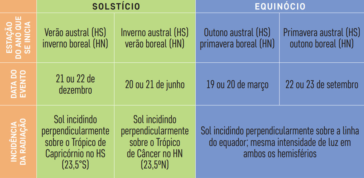
The spring and autumn seasons begin when the Sun's rays directly hit the equator (0° latitude). In the Southern Hemisphere, when this occurs after summer, on March 19 or 20, austral autumn begins, and when it occurs after winter, around September 22 or 23, austral spring begins. These dates are called the Equinoxes. On these specific dates, both hemispheres receive the same amount of solar radiation.
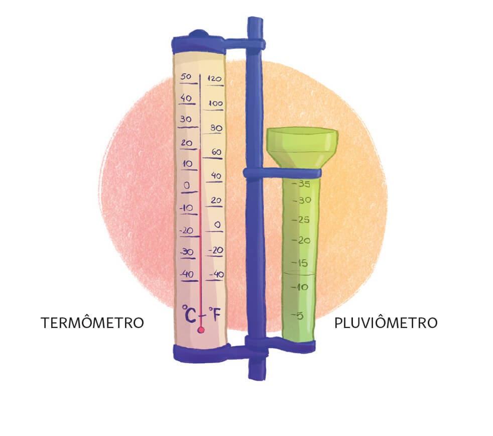
The term weather is used to refer to the momentary state of the atmosphere, that is, what we perceive from the atmosphere in our daily lives, such as a cloudy morning, a sunny afternoon, a cold or hot day, etc. Climate, on the other hand, refers to the average state of the atmosphere, i.e. the average of weather events over a long period. To know the climate of a given region, we use, for example, information from meteorological stations, satellites, ocean buoys, which record values of atmospheric variables such as air temperature, precipitation, relative humidity, atmospheric pressure, etc, taken over a very long period of time. According to the World Meteorological Organization (WMO or WMO), climate is defined as the average of these variables over a period of 30 years.
So, now you know: when someone says “Wow, the climate is very dry today!” or “The climate will warm up this week!”, you can answer that the choice of the word “climate” is not correct in the sentence; the correct thing would be to say: “Wow, the weather is very dry today!” or “The weather will warm up this week!”.
Usually in meteorology we consider that in the Southern Hemisphere the months from December to February (DJF) correspond to summer, from March to May (MAM) to autumn, from June to August (JJA) to winter and from September to November (SON) to spring. That is, there are official dates for the beginning of the seasons, however, in practice, in Earth sciences, we consider quarters with complete months.
When we say austral we mean the Southern Hemisphere (SH) and when we say boreal, we mean the Northern Hemisphere (NH).
Do you know why the Sun rises in the East sector and sets in the West sector?
Because of the direction of the Earth’s rotation, which is from West to East (that is, the Earth rotates counterclockwise if we imagine a cut looking at the planet above the North Pole). This causes the apparent movement of the Sun in the East-West orientation.
What are the East and West cardinal points?
These are the points where the celestial equator (which is the extension of Earth's equator in the sky) crosses the horizon.
Does the Sun always rise exactly at the East cardinal point and set at the West?
No, the Sun rises exactly at the East point and sets exactly at the West point only on the Equinoxes dates, which mark the entrance of the autumn and spring seasons. On these specific days, day and night are equal in length to 12 hours. In the Southern Hemisphere, after the beginning of spring and during the summer, the Sun rises to the right of the East, further South, while after the beginning of autumn and during the winter, the Sun rises to the left of the East, further North.
The dates and times of the solstices and equinoxes vary, as the year has approximately 365.2422 days, that is, it is not an exact number. Leap years (which have 366 days) exist as a way of “compensating” for this variation. This ends up influencing the start of a new season each year when compared to the previous year.
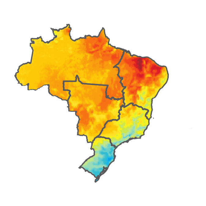
Brazil is a country of continental dimensions, that is, with an expressive territorial extension. Because of this, the climate in Brazil is not exactly the same throughout the country, that is, different regions have different climate characteristics, which also vary throughout the year. We already know that the different seasons of the year (summer, autumn, winter and spring) occur due to variations in the incidence of solar radiation received on our planet, as it revolves around the Sun (translation) with its axis of rotation inclined. We also know that, in meteorology, the main variables used to characterize the climate in a given region are temperature and precipitation. Bearing these concepts in mind, we will analyze the following figures. They illustrate, in terms of temperature and precipitation, the average climatological values observed in Brazil in each of the seasons. The climatological period considered to compute these average values encompasses all years from 1981 to 2010.
The South region has four well-defined seasons; the rain occurs regularly throughout the year, while the temperature presents greater variations between the different seasons of the year. In summer, the maximum temperatures exceed 30ºC, but the thermal amplitude is smaller, that is, the difference between the absolute value of the minimum and maximum temperatures of the day is smaller. In spring and autumn, maximum temperatures can even reach 30ºC, but the thermal amplitude observed throughout the day is generally higher, with minimum temperatures of around 10ºC. In winter, minimum temperatures close to 0ºC are common, as well as frost.
In other regions of Brazil, the seasons of the year are better defined in terms of rain, so that most of the time we end up referring to two distinct patterns: the dry season and the rainy season. In between, there are the transition seasons, in which it rains sporadically and briefly. The rainy season, as the name implies, has torrential rains and takes place in the hottest months (November to March) over the North, Central-West and Southeast regions. The dry season in these same regions occurs between April and September, when the accumulated rainfall is significantly lower compared to the rainy season. In the Southeast and South of the Central-West, minimum temperatures during the dry season are generally lower, and frosts may occur in rare cases. In the Central-West, the spring and summer seasons have the highest temperatures, while during the dry season in the North the average temperatures are higher than during the rainy season, which is due to the lower amount of clouds in the sky that allows for greater heating by the Sun.
The Northeast region of Brazil also has dry and rainy seasons; the rainy season occurs in February, March, April and May, with more abundant rain distributed over the entire region. In June, July and August, it also rains a lot on the coastal Northeast region, although in the rest of the region the accumulated rainfall is much smaller. During the rest of the year, the dry season occurs, when the rains practically cease. On the other hand, temperatures are approximately constant throughout the year, with low thermal amplitudes.
Frost is a meteorological phenomenon that occurs when the air temperature is very low, close to 0°C. This usually occurs at night, where, in the absence of winds, clouds and solar radiation, heat is lost from surfaces close to the ground (radiative loss). In this way, the water vapor contained in the air will change to a liquid state, that is, it condenses, forming dew, which in turn is formed by water droplets deposited on plants and objects. With the continuous cooling of the air close to the ground, the dew is then frozen. Frost can also occur when water vapor suspended in the air very close to the ground is turned into ice crystals, precipitating (falling). In Brazil, conditions for frost formation are especially found south of 19ºS, which comprises the states of São Paulo, Mato Grosso do Sul, Minas Gerais, Paraná, Santa Catarina and Rio Grande do Sul in the months of June and July, but can also occur from April (mid-autumn) to September (known as late- or spring-frost).
Thermal amplitude: is the difference between the maximum and minimum temperatures of a given location and period of time. For example, daily temperature range, monthly temperature range, annual temperature range, etc. Thermal amplitudes occur due to factors that control how the solar radiation heats the Earth's surface and its adjacent air and how the terrestrial radiation is redistributed. These factors are: height of the Sun above the horizon, intensity and duration of solar radiation that falls on the Earth's surface, type of surface (sand, snow, bare soil, grassland, forest, etc.), cloud cover, amount of greenhouse gases. Therefore, it is possible to observe that there are natural determinants for the thermal amplitude to occur in different time scales, such as the latitude of the place, the time of day and the day of the year.
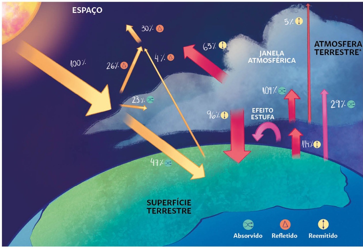
The Earth's atmosphere is composed of several gases and small particles (aerosols) that play a fundamental role in regulating the energy balance on our planet. And it is this balance, which always tends to seek equilibrium, that controls the Earth's climate.
Let's review some important concepts about the terrestrial energy balance:
We know that any body with a temperature above absolute zero (0 Kelvin) emits and absorbs radiation, and that the radiation emitted by the Sun is the main source of energy that continuously feeds the Earth system.
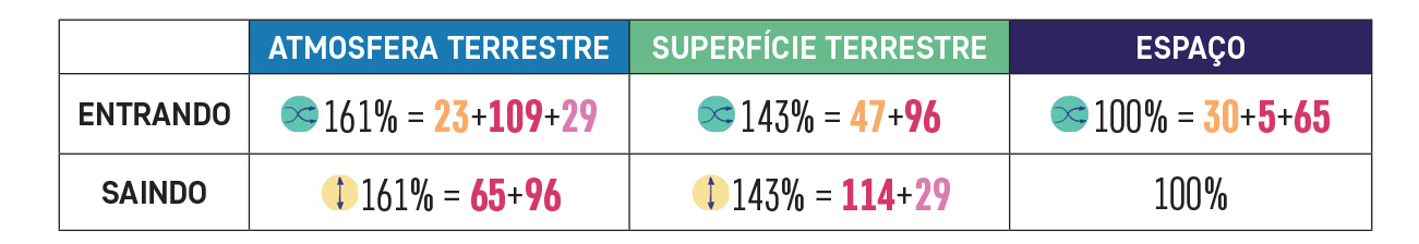
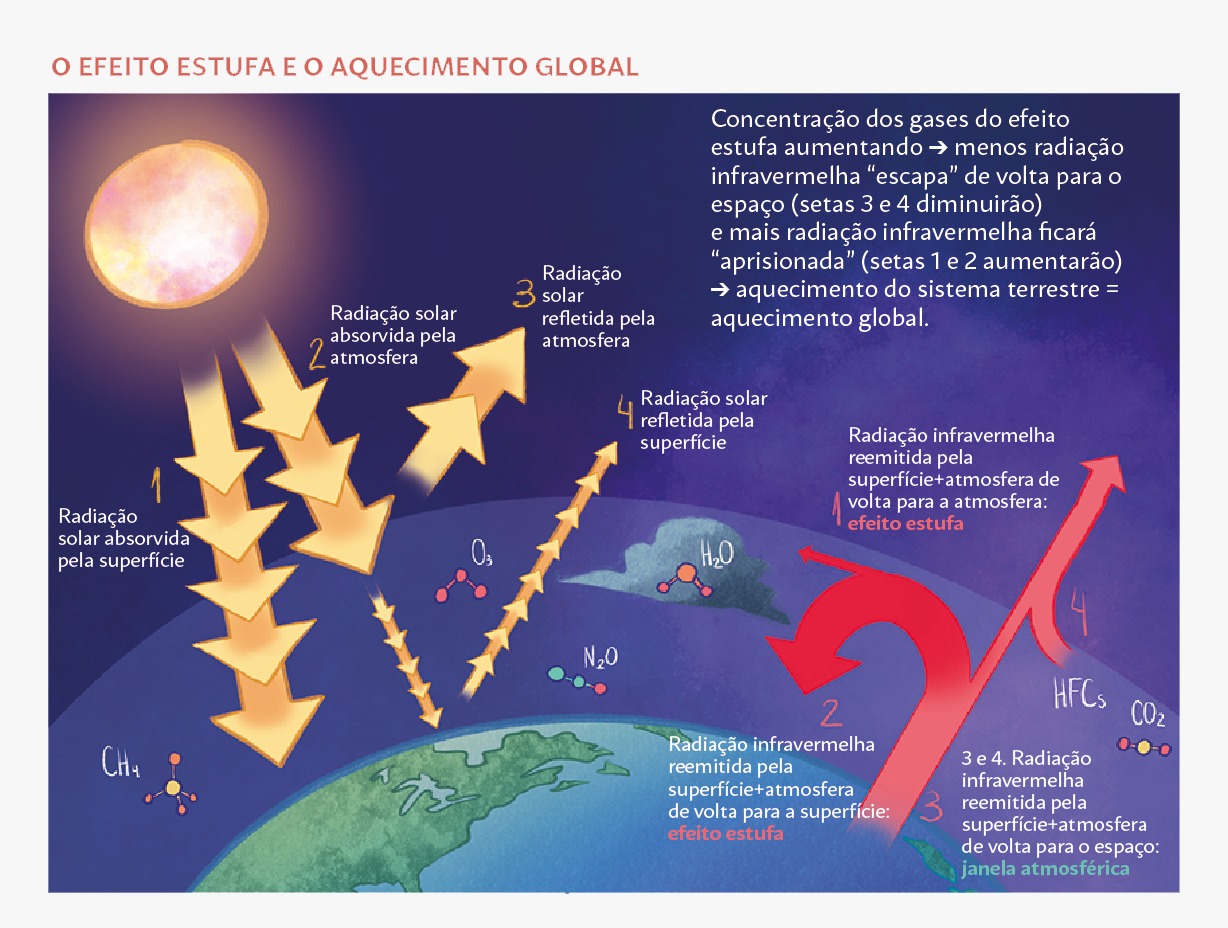
Upon reaching our atmosphere, part of the solar radiation (about 30%) is reflected back into space, and the other part (about 70%) is absorbed by our atmosphere and the Earth's surface.
Such absorption of solar energy results in the heating of the Earth system, which in turn emits infrared radiation in all directions; such emission of infrared energy leads to a consequent cooling of the terrestrial system, so that the energy balance always tends to seek equilibrium; this balance means that almost all the solar energy that “arrives” to Earth is “returned” to space, in the form of infrared energy.
However, as mentioned, not all of the emitted infrared energy returns to space. Thanks to the presence of some specific components in our atmosphere, which have the property of absorbing infrared radiation, part of this energy that should return to space ends up being trapped by the atmosphere and returning to the Earth's surface, as part of the process known as the "greenhouse effect". It is this greenhouse effect that causes the Earth to have temperatures and other climate characteristics compatible with the generation and maintenance of life and the terrestrial ecosystem. The global average temperature at the Earth's surface is around 15°C.
Without the greenhouse effect, the average temperature on the Earth's surface would be much lower (around -18ºC) and incompatible with most life as we know it; the oceans, for example, would all be frozen.
The main atmospheric constituents responsible for the greenhouse effect are: water vapor (50%), clouds (25%), carbon dioxide (CO2; 20%), and many others (5%), including methane (CH4), nitrous oxide (N2O), ozone (O3) and hydrofluorocarbons (HFCs).
Infrared radiation is a form of energy associated with the temperature of the body that emits it; any body with a temperature greater than absolute zero emits this type of energy, which is invisible to our eyes.
Although CO2 is the second most important greenhouse gas, after water vapor, which is by far the most abundant in our atmosphere, the role that this gas plays in the terrestrial energy balance is crucial.
The increase in CO2 in the atmosphere (which we will see later is a direct result of human actions) results in an “excess” of greenhouse gases, which consequently increases the amount of infrared energy returning to the Earth's surface instead of "escaping" into space. This causes a greater warming of the Earth's climate system, which has been observed to be associated with the unfolding of the Industrial Revolution, and is popularly referred to as global warming.
But how can the Earth be warming if we often read news about regions where record cold temperatures are registered?
Just as some regions of the globe experience record cold temperatures, other regions experience record warm temperatures. The global warming to which we refer concerns the average value recorded over the entire globe. What has actually been observed is an increase in extreme weather events across the planet; these extreme events can be, for example, heat waves or cold waves; heavy rains/floods or severe droughts. And we should be concerned about this, as these extreme weather events bring with them a great potential for disasters, damages and losses, both economic and human.
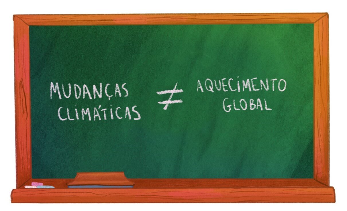
While we often hear the terms “global warming” and “climate change” interchangeably, technically there are some differences in the definition of each term. As we have seen, the term “global warming” refers to the increase in the average temperature of the Earth system that occurs as a result of the increase in the concentration of greenhouse gases in our atmosphere. The term “climate change” refers to the consequent long-term changes that have been observed (over the last few decades) and projected (in future decades) in multiple climate variables (such as precipitation, temperature and wind patterns); these changes stem from both anthropogenic (ie, human-caused) and natural factors (Earth’s internal climate variability and other external forcings) and have a wide variety of effects on various aspects of geophysical, natural and human systems.
Earth's climate has not always been as we currently know; throughout its history, which began more than 4.5 billion years ago, our planet has gone through several periods of climate change, alternating periods of ice ages and interglacial periods, caused by heating from the natural greenhouse effect. These fluctuations occurred as a result of natural forcings (such as meteorite impacts, volcanic eruptions, and variations in the Earth's orbit and solar energy) that have always existed and will continue to exist in the future. However, this is the first time in Earth's history that climate change is occurring as a result of human actions. And these anthropogenic changes have been occurring at high speed, much faster than natural changes associated with variations in the Earth's orbit, for example.
There are several indicators that the climate has been changing since the mid-20th century; Scientists from different areas of knowledge and from all over the world have been warning society about these changes and their implications for a long time now. The Intergovernmental Panel on Climate Change, popularly known by its acronym, IPCC, was created in 1988 by the World Meteorological Organization and the United Nations Environment Program (UN Environment), in an attempt to combine the efforts of experts from all over the world and improve our understanding of climate change and all the complex scientific, technical and socio-economic issues involved. The IPCC is organized into Working Groups and periodically releases detailed and comprehensive reports and summaries for government decision-makers; all information is also freely accessible to the general public.
Evidence that the climate is changing includes:
Increase in the average temperature on the Earth's surface, which can be proven through local measurements across the globe and through data from satellites orbiting the Earth;
Increase in ocean acidification, which occurs due to the higher concentration of CO2 in the atmosphere that ends up being absorbed by the oceans;
Decrease in the volume of sea ice in the Arctic, which has been observed in recent decades;
Melting glaciers around the world;
Sea level rise, which globally has increased by about 23 centimeters since 1980, due to both the expansion of warming ocean water and the melting of glaciers and ice sheets on land;
Increased frequency and intensity of extreme events, which are related to observed changes in the global water cycle (with long and severe droughts in some regions and increased annual precipitation in other regions).
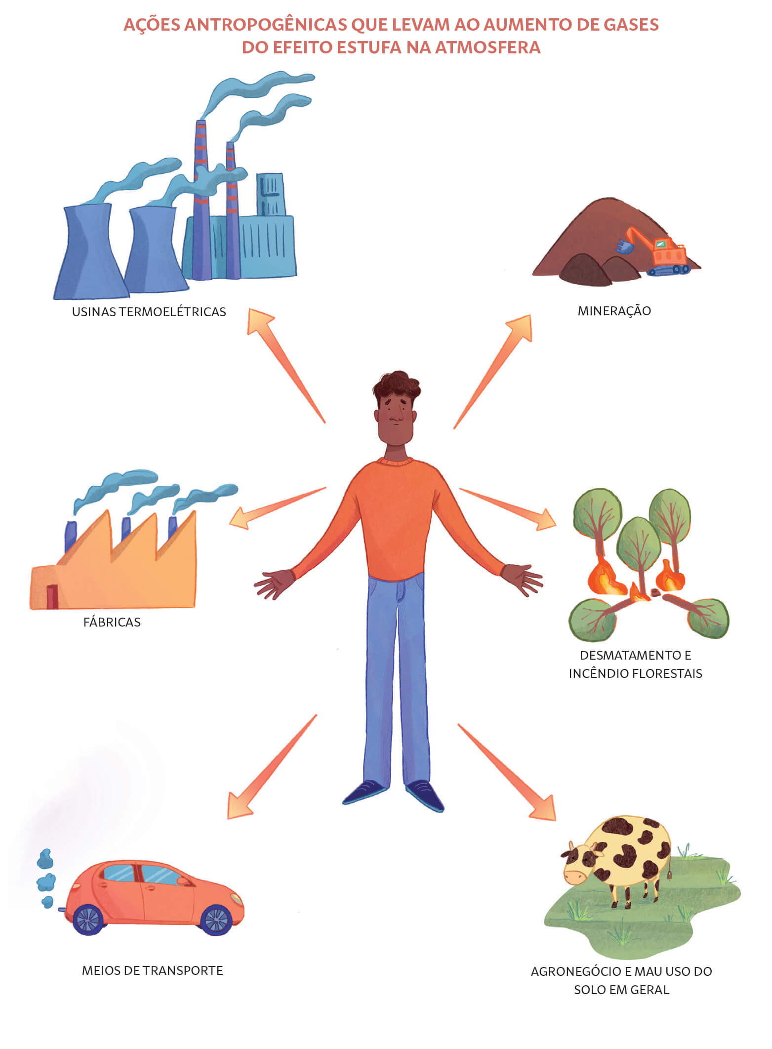
There is empirical evidence that the increase in greenhouse gases that has been observed is a reflection of the high emission of pollutants into our atmosphere by human activities associated with the Industrial Revolution, which began in 1760. The advance of industrial and production technologies, at the same time that allowed us to reach great achievements, also ended up generating an immense amount of pollutants due to the burning of fossil fuels, which is used to produce energy and mechanical work. Nowadays, it is possible to see that almost everything around us derives from processes that involve the burning of fossil fuels: the production of electricity, means of transport, various products built through industrial processes, among others. And it's not just the burning of fossil fuels that generates greenhouse gases; deforestation, misuse of land in agribusiness in general (livestock, agricultural land, rice production), and coal mining are also processes that contribute to this.
There is already a majority consensus among experts in the scientific community that climate change is indeed occurring, and that human actions are indeed responsible for it. A study published in 2013, led by Dr. John Cook of the Global Change Institute, University of Queensland, Australia, showed that the overwhelming majority (97%) of scientists agree that the anthropogenic (i.e., human-caused) increase in concentration of greenhouse gases is the main cause of the global warming that has been observed. The fifth IPCC report also concluded that the human influence on the Earth's climate is clear, and there is a high degree of confidence (more than 95% probability) that human activities over the last 50 years are responsible for the observed warming in our planet.
In addition to the generation of greenhouse gases, the emission of pollutants also produces aerosols, which can interact with solar radiation and affect the formation of clouds, which consequently can alter the energy balance in the Earth system and contribute to climate change.
Changes in the way humans use land (e.g. forests, farms or cities) can also cause local effects, altering the reflectivity of the Earth's surface and changing the level of humidity in a region.
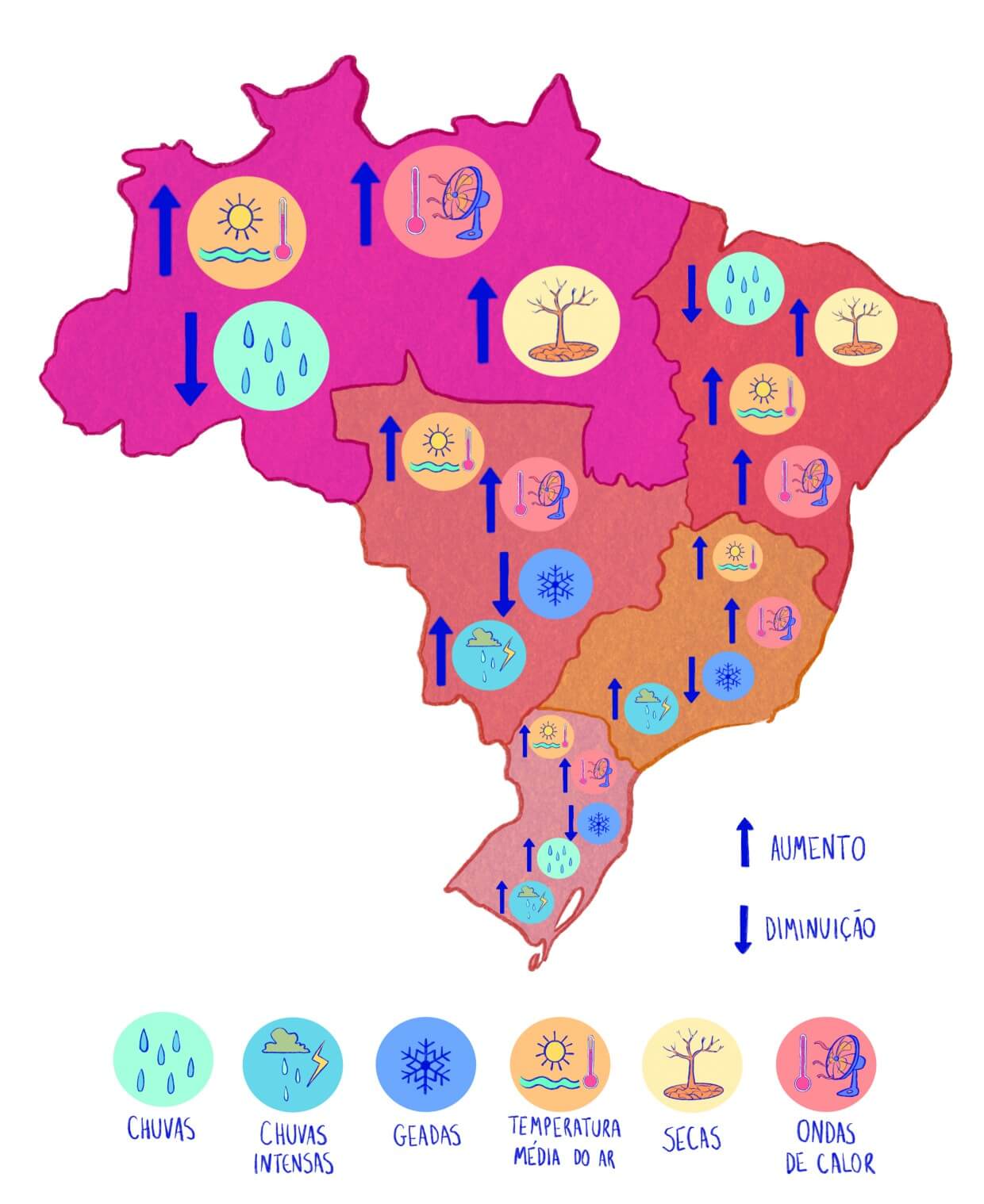
IPCC reports have shown that global warming will change the climate in Brazil in such a way that the temperature is expected to increase throughout the country. A warmer climate will lead to a reduction in frost in the South, Southeast and Central-West regions of Brazil. The impacts on precipitation will occur in different ways depending on the region. For example, very intense precipitation may occur more frequently in the South and Southeast regions, while the rainy seasons and the intensity of rainfall in the North and Northeast regions are expected to decrease. Along with higher temperatures, the decrease in rainfall will make Amazonian ecosystems in the North of the country more susceptible to a possible collapse, reducing or even modifying their vegetation. In the case of the Northeast region, the increase in temperature alone could exacerbate existing problems with droughts, causing greater evaporation of water from reservoirs, lakes and rivers. The following map illustrates the main impacts and projected effects for Brazil's climate by 2100.
As we have seen, global warming is already underway, climate change is already happening and it is noticeable all over the world. Unfortunately, it is no longer possible to avoid it. However, it is still possible to mitigate it by reducing global emissions of greenhouse gases. In this regard, an agreement was made between several countries, including Brazil, at the Conference of the Parties in Paris in 2015. The agreement determines that efforts are made to reduce global CO2 emissions and stop or reduce global deforestation. As a result, global warming is expected to stay below 2°C in the coming decades. For us to succeed in this endeavor, we need to address large-scale issues such as using cleaner transportation, generating cleaner energy, producing sustainable food, and reducing or ending fires. Brazil has committed, through the approval of its National Congress in 2016, to increase the share of sustainable bioenergy (ie, the energy produced from organic matter of plant and animal origins), to approximately 18% and to increase the proportion of renewable energy in the energy matrix to approximately 45% by 2030. In addition, Brazil is committed to restoring and reforesting 12 million hectares of forests. Our individual efforts can also help to contain the emission of greenhouse gases in the long term, through small daily actions, such as, for example, less waste production and better waste treatment, active or public transport, more conscious consumption of water and electrical energy, etc.

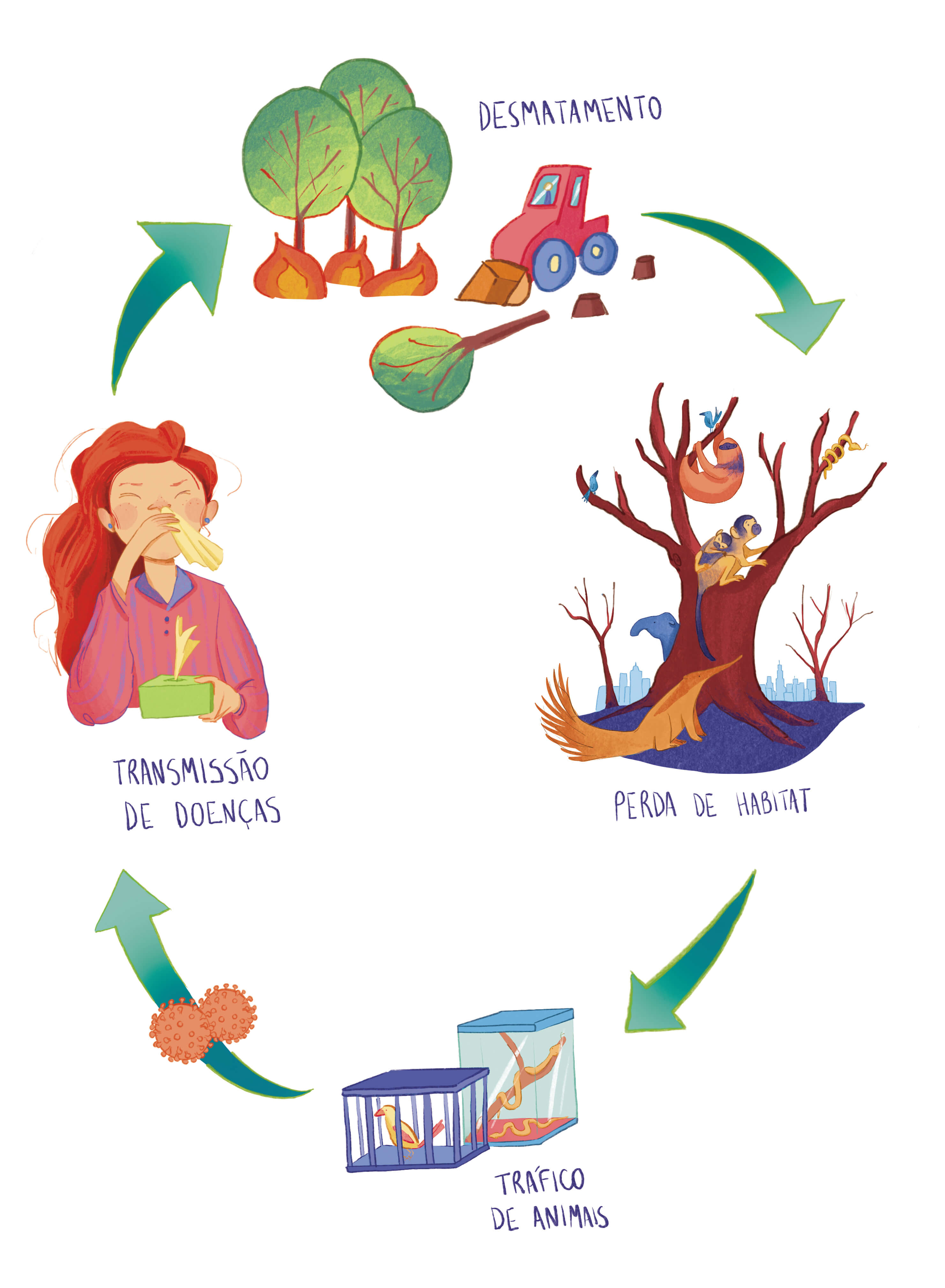
The COVID-19 pandemic has been one of the great challenges of the 21st century, causing several impacts on health, human and economic losses. The cause of COVID-19 is still being investigated and several hypotheses suggest that one of the paths for its emergence and spread, as well as for several other emerging infectious diseases, is anthropogenic interference on the environment and global warming. In fact, the United Nations Environment Program points out that this is the path of several other emerging zoonoses (infectious diseases transmitted by animals to humans) (examples: SARS, MERS, Ebola, etc). Although climate change was not the direct cause of the emergence of COVID-19, there are possible interrelationships between them. Deforestation, global warming and loss of natural habitats make animals more susceptible to capture and trafficking. This increasing co-location between wild and domestic animals and humans facilitates the spread of infectious diseases. On the other hand, to try to contain the spread of the virus that causes COVID-19, SARS-CoV-2, many countries adopted restrictive measures, making people stay indoors, avoiding crowds on the streets and in shops/markets in general. These restrictions led to a temporary reduction in greenhouse gases, such as CO2, which had a significant reduction during the first half of 2020. This shows that our consumption and living habits need to be rethought and modified if we want to live on a healthier planet.
ALVES, L. M. Clima da região Centro-Oeste do Brasil. In: CAVALCANTI, I. D. A.; FERREIRA, N. J.; DA SILVA, M. G. A. J.; SILVA DIAS, M. A. F. (Orgs.). Tempo e Clima no Brasil. São Paulo: Oficina de Textos, 2009, p. 235-241.
AMBRIZZI, T. et al. The state of the art and fundamental aspects of regional climate modeling in South America. Annals of the New York Academy of Sciences, v. 1436, n. 1, p. 98-120, 2019.
BEDAQUE, P.; BREDONE P. S. Variação da posição de nascimento do Sol em função da latitude. Revista Brasileira de Ensino de Física, v. 38, n. 3, e3307, 2016.BRASIL. Ministério do Meio Ambiente. Pretendida Contribuição Nacionalmente Determinada Para Consecução Do Objetivo Da Convenção-Quadro Das Nações Unidas Sobre Mudança Do Clima. Disponível em: https://www.mma.gov.br/clima/convencao-das-nacoes-unidas/acordo-de-paris/item/10710.html. Acesso em 12 de agosto de 2020.
BRITO, S. B. P. et al. Pandemia da COVID-19: o maior desafio do século XXI. Vigilância Sanitária em Debate: Sociedade, Ciência & Tecnologia, v. 8, n. 2, p. 54-63, 2020.
COOK, J. et al. Quantifying the consensus on anthropogenic global warming in the scientific literature. Environmental Research Letters, v. 8, n. 2, 024024, 2013.
FORTUNE, M. A.; KOUSKY, V. E. Two Severe Freezes in Brazil: Precursors and Synoptic Evolution. Monthly Weather Review, v. 111, p. 181–196, 1983.
GRIMM, A. M. Clima da região Sul do Brasil. In: CAVALCANTI, I. D. A.; FERREIRA, N. J.; DA SILVA, M. G. A. J.; SILVA DIAS, M. A. F. (Orgs.). Tempo e Clima no Brasil. São Paulo: Oficina de Textos, 2009, p. 259-275.
IPCC. Climate Change 2013: The Physical Science Basis. Contribution of Working Group I to the Fifth Assessment Report of the Intergovernmental Panel on Climate Change [Stocker, T.F., D. Qin, G.-K. Plattner, M. Tignor, S.K. Allen, J. Boschung, A. Nauels, Y. Xia, V. Bex and P.M. Midgley (eds.)]. Cambridge University Press, Cambridge, United Kingdom and New York, NY, USA, 2013, p. 1535.
______. Climate Change 2014: Synthesis Report. Contribution of Working Groups I, II and III to the Fifth Assessment Report of the Intergovernmental Panel on Climate Change [R.K. Pachauri and L.A. Meyer (eds.)]. IPCC, Geneva, Switzerland, 2014, p. 151.
MARENGO, J. O futuro clima do Brasil. Revista USP, São Paulo, n. 103, p. 25-32, 2014.
______. Drought, Floods, Climate Change, And Forest Loss In The Amazon Region: A Present And Future Danger? Frontiers for Young Minds, v. 7, p. 8-147, 2020.
MARGULIS, S.; DUBEUX, C. B. S.; MARCOVITCH, J. The economics of climate change in Brazil: costs and opportunities. São Paulo: FEA/USP, 2011.
OLIVEIRA, G. S.; DA SILVA, N. F.; HENRIQUES, R. Mudanças climáticas: ensino fundamental e médio. Brasília: MEC, SEB; MCT; AEB, 2009.
PAINEL BRASILEIRO DE MUDANÇAS CLIMÁTICAS (PBMC). Base Científica das Mudanças Climáticas. Contribuição do Grupo de Trabalho 1 do Painel Brasileiro de Mudanças Climáticas ao Primeiro Relatório de Avaliação Nacional sobre Mudanças Climáticas. Ambrizzi, T; Araujo, M (Orgs.). Rio de Janeiro: Coppe/Universidade Federal do Rio de Janeiro, 2014.
PROGRAMA DAS NAÇÕES UNIDAS PARA O MEIO AMBIENTE (PNUMA). UN environment programme, 2020. Ementa (descrição). Disponível em: https://www.unenvironment.org/pt-br/noticias-e-reportagens/reportagem/6-fatos-sobre-coronavirus-e-meio-ambiente. Acesso em: 10 de setembro de 2020.
REBOITA, M. S. et al. Regimes de precipitação na América do Sul: uma revisão bibliográfica. Revista brasileira de meteorologia, v. 25, n. 2, p. 185-204, 2010.
REBOITA, M. S. et al. Entendendo o Tempo e o Clima na América do Sul. Terra e Didática, v. 8, n. 1, p. 34-50, 2012.
SILVA DIAS, M. A. F.; da SILVA M. G. A. J. Para Entender Tempo e Clima. In: CAVALCANTI, I.D.A.; FERREIRA N.J.; DA SILVA, M. G. A. J.; SILVA DIAS, M. A. F. (Orgs). Tempo e Clima no Brasil. São Paulo: Oficina de Textos, 2009, p. 15-21.
WENDEL, J. Will COVID’s cleaner skies muddy climate models? Eos, 101, 2020. Disponível em: https://eos.org/articles/will-COVIDs-cleaner-skies-muddy-climate-models
YNOUE, R. Y. et al. Meteorologia: noções básicas. São Paulo: Oficina de Textos, 2017.
YNOUE, R. Y. et al. Meteorologia: noções básicas. São Paulo: Oficina de Textos, 2017.
Texts: Tércio Ambrizzi, Amanda Rehbein, Lívia Márcia Mosso Dutra, Natália Machado Crespo
Cover (illustration and art) donated by: Júlia Rehbein Garcia
Graphic coordination and internal design: Angela Mendes
Internal illustrations: Fran Matsumoto
Web design and development: Lucas Raposo
Quiz (design e coding): Lucas Raposo
Translation: Amanda Rehbein, Lívia M. M. Dutra
Revision: Lívia M. M. Dutra, Robert Lee
Institute of Astronomy, Geophysics and Atmospheric Sciences, University of São Paulo
GrEC/IAG/USP - Sala P-213
Rua do Matão, 1226 - Cidade Universitária - São Paulo, SP
05508-090 BRASIL
Email: incline.aca@iag.usp.br
.jpg)